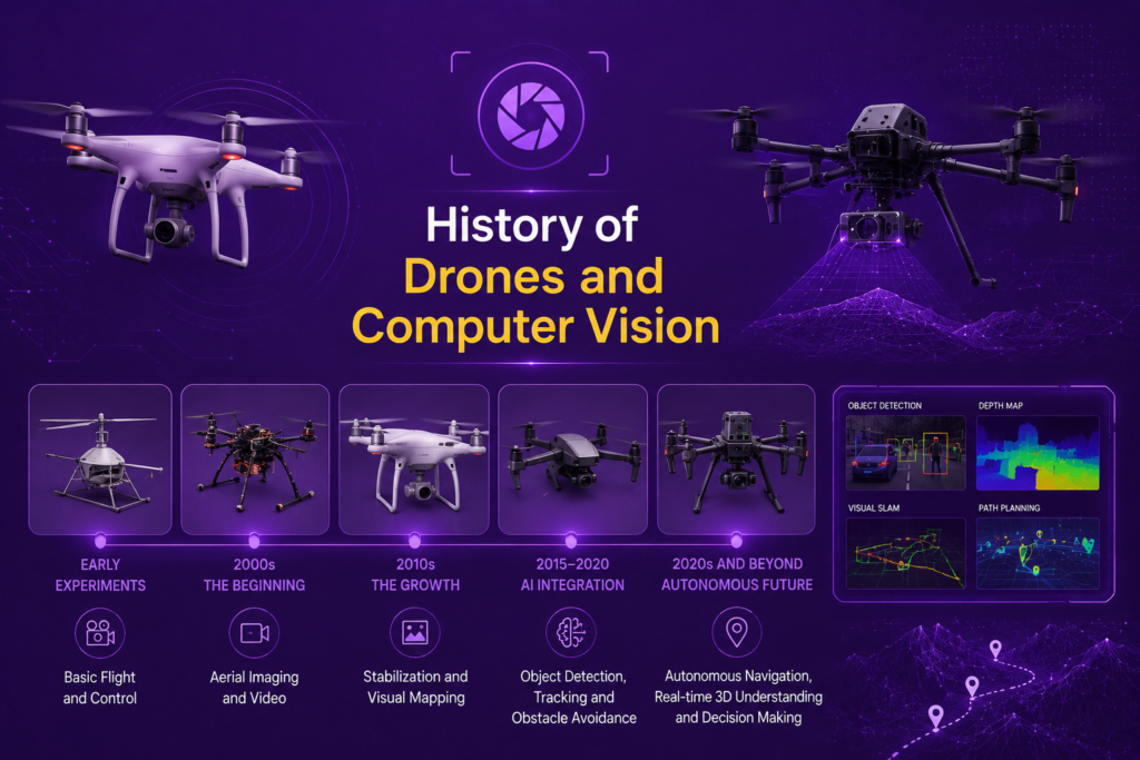
A drone without computer vision is, in many ways, just a remote-controlled flying camera. It can capture footage, but it cannot understand what it is looking at, avoid obstacles on its own, or navigate without a human pilot constantly watching a video feed and making every decision. The story of drones and computer vision is the story of how flying robots gained the ability to perceive and interpret the world around them, transforming drones from simple remote-controlled devices into genuinely autonomous systems capable of mapping, inspecting, tracking, and navigating largely on their own.
Early Drones: Flying Cameras Without Vision
Unmanned Aerial Vehicles (UAVs) have existed in various forms for decades, predominantly in military contexts, long before the broader history of computer vision had advanced enough to give these vehicles any meaningful ability to interpret their surroundings. Early drones were essentially remote-controlled aircraft, flown by human operators based on live video feeds, with the aircraft itself contributing little beyond stability and basic flight control.
This relationship began to change as advances throughout the broader history of object detection and related fields became computationally feasible on smaller, lighter hardware suitable for installation on aircraft with limited payload capacity and power budgets. The fundamental challenge for drones and computer vision has always involved this constraint: drones need to carry their own power source and computing hardware, meaning that any computer vision system running on a drone needs to be efficient enough to operate within these tight resource limits.
Optical Flow and Early Stabilization (2000 – 2010)
Optical flow stabilization represents one of the earliest practical applications of computer vision techniques on drones. Optical flow refers to the pattern of apparent motion of objects in a visual scene, caused by the relative motion between the camera and the scene. By analyzing optical flow from a downward-facing camera, a drone could estimate its own movement relative to the ground, providing valuable information for maintaining stable flight, particularly in situations where GPS signals might be weak or unavailable, such as indoors or in urban canyons surrounded by tall buildings.
This early application of computer vision connects directly to the broader history of image processing, since optical flow estimation relies on analyzing changes between consecutive video frames, a technique with roots extending back through decades of computer vision research. For drones specifically, optical flow based stabilization represented one of the first instances where computer vision moved from being purely about capturing imagery to actively informing flight control.
Aerial Photogrammetry and Mapping (2010 – 2015)
Aerial photogrammetry mapping became one of the most commercially significant early applications connecting drones and computer vision. Photogrammetry involves reconstructing three-dimensional information about a scene from multiple two-dimensional photographs taken from different positions, a technique that predates drones considerably but that drones made dramatically more accessible and affordable.
Ground control points (GCP), precisely surveyed reference points placed within the area being mapped, became an important component of accurate drone-based photogrammetry, providing known reference locations that could be used to calibrate and verify the accuracy of maps generated from drone imagery. Drone camera survey data processing software developed during this period to stitch together hundreds or thousands of individual photographs into accurate maps, three-dimensional models, and elevation data.
This application connects to the broader history of image processing, since combining multiple overlapping images into a single coherent map or model relies on techniques for identifying corresponding features across images, similar in spirit to the feature matching techniques discussed in relation to the history of object detection and related computer vision tasks.
Real Time Object Detection for Drones (2015 – 2020)
Real time object detection for drones became increasingly practical following the broader deep learning transformed computer vision revolution. Architectures from the history of yolo in particular became popular for drone applications, given their emphasis on speed and their ability to run effectively on the kind of compact, power-efficient hardware that drones could realistically carry.
Drone collision avoidance vision systems represent one of the most safety-critical applications of object detection technology on drones. By identifying obstacles, other aircraft, buildings, trees, power lines, in real time, a drone could adjust its flight path automatically to avoid collisions, a capability essential for any drone operating autonomously rather than under constant human control with a clear line of sight.
Drone computer vision tracking systems also developed significantly during this period, allowing drones to identify and follow specific subjects, whether for cinematography applications tracking a moving subject for filming, search and rescue applications tracking a person of interest, or agricultural applications tracking equipment or livestock across a field.
Edge AI Computer Vision on Drones (2018 – 2024)
Edge AI computer vision on drones reflects the broader trend of running increasingly sophisticated deep learning models directly on the drone itself, rather than transmitting video to a ground station for processing. Low-latency edge inference became essential for applications like collision avoidance, where the delay involved in transmitting video to a remote processing system and receiving instructions back could be the difference between successfully avoiding an obstacle and a collision.
This shift required significant advances in efficient neural network architectures and specialized hardware capable of running these architectures within the power and weight constraints of drone platforms. The broader history of object detection, including efficient architectures within the YOLO vs R-CNN vs SSD comparison, has been particularly influential here, since the speed advantages of architectures like the history of yolo translate directly into the kind of low-latency performance that safety-critical drone applications require.
Fixed-wing vs quadcopter perception represents an important practical distinction in how computer vision systems are deployed across different drone types. Fixed-wing drones, which generally fly faster and cover larger areas, often prioritize computer vision systems optimized for mapping and survey applications across large areas. Quadcopters, which can hover and maneuver more precisely, often prioritize computer vision systems optimized for close-range inspection, tracking, and obstacle avoidance in more confined spaces.
Autonomous Navigation Without GPS
Autonomous drone navigation using computer vision becomes particularly important in environments where GPS signals are unreliable or unavailable entirely, such as indoor spaces, dense urban environments, underground areas, or environments specifically designed to deny GPS access. Visual SLAM navigation for autonomous drones addresses this challenge directly, using camera input to simultaneously build a map of the environment and track the drone’s position within that map, without relying on external positioning signals.
UAV image processing algorithms supporting visual SLAM and related navigation approaches connect to the broader history of depth estimation and history of pose estimation, since accurately understanding the drone’s position and orientation relative to its surroundings requires extracting spatial information from camera images, often combined with other sensors like inertial measurement units that track acceleration and rotation.
Automated flight pathing represents a further capability building on these navigation foundations, allowing drones to plan and execute complex flight paths automatically, adjusting in real time based on what their computer vision systems detect, rather than following a predetermined path regardless of changing conditions.
Precision Agriculture and Specialized Applications (2015 – 2026)
Computer vision for precision agriculture drones represents one of the most economically significant applications connecting drones and computer vision. Agricultural drones equipped with computer vision systems can identify crop health issues, detect pest infestations, estimate yields, and guide precise application of water, fertilizer, or pesticides only where needed, rather than uniformly across an entire field.
Thermal imaging computer vision for drones extends these capabilities beyond the visible spectrum. By processing thermal imagery alongside or instead of standard visible light imagery, drones can identify temperature variations invisible to the naked eye, useful for applications ranging from identifying irrigation issues in agriculture to locating people in search and rescue operations, to detecting heat signatures in industrial inspection contexts.
Spatial mapping payloads have become increasingly sophisticated, often combining multiple sensor types, visible light cameras, thermal cameras, and sometimes additional sensors like multispectral cameras that capture information beyond standard color channels, all processed through computer vision systems to extract useful information for specific applications.
Real-Time Scene Understanding
Real-time semantic layout tracking represents an increasingly important capability for advanced drone applications. Rather than simply detecting individual objects, semantic layout tracking involves understanding the broader structure of a scene, identifying not just that something is present but understanding the relationships between different elements, the layout of a field, the structure of a building being inspected, or the progression of a construction site over time.
This connects to the broader history of image segmentation and reflects how computer vision capabilities developed for other applications, including self-driving cars and computer vision and computer vision in manufacturing, increasingly find their way into drone applications as well, given the underlying similarities in the kinds of scene understanding these different applications require.
Frequently Asked Questions
How do drones use computer vision for navigation?
Drones use computer vision for navigation through techniques like optical flow analysis, which estimates movement based on changes between video frames, and visual SLAM, which builds a map of the environment while simultaneously tracking the drone’s position within it. These techniques are particularly important in environments where GPS signals are unreliable, such as indoors or in dense urban areas.
What is the role of computer vision in drone collision avoidance?
Computer vision enables drones to detect obstacles, other aircraft, and hazards like power lines or trees in real time using object detection techniques. By identifying these obstacles and their positions relative to the drone, the system can automatically adjust the flight path to avoid collisions, a critical capability for autonomous drone operation.
How are drones used in precision agriculture?
Drones equipped with computer vision systems can fly over agricultural fields and identify crop health issues, pest infestations, and irrigation problems, often using thermal or multispectral imaging in addition to standard cameras. This information helps farmers apply water, fertilizer, or pesticides precisely where needed, improving efficiency and reducing waste.
Why is edge AI important for drone computer vision?
Edge AI allows drones to run computer vision processing directly onboard, rather than transmitting video to a ground station for analysis. This reduces latency significantly, which is essential for safety-critical applications like collision avoidance, where delays in processing and response time could result in accidents.
What is aerial photogrammetry?
Aerial photogrammetry is the process of reconstructing accurate maps, three-dimensional models, or elevation data from multiple overlapping photographs taken from a drone at different positions. By combining these images and often using ground control points for calibration, photogrammetry software can produce highly accurate representations of the surveyed area.
Conclusion
The history of drones and computer vision is a story of flying robots gradually gaining the ability to understand, rather than just record, the world beneath them. From early optical flow based stabilization, through the rise of aerial photogrammetry and mapping, to today’s real time object detection, collision avoidance, and autonomous navigation systems running directly on the drone itself, each advance has expanded what drones can do without constant human guidance.
As computer vision technology continues to advance, the relationship between drones and computer vision will likely continue deepening, with drones taking on increasingly complex perception and decision-making tasks across agriculture, inspection, mapping, search and rescue, and countless other applications. Understanding this history means understanding how decades of computer vision research have come together to give machines not just the ability to fly, but the ability to truly see where they are going.