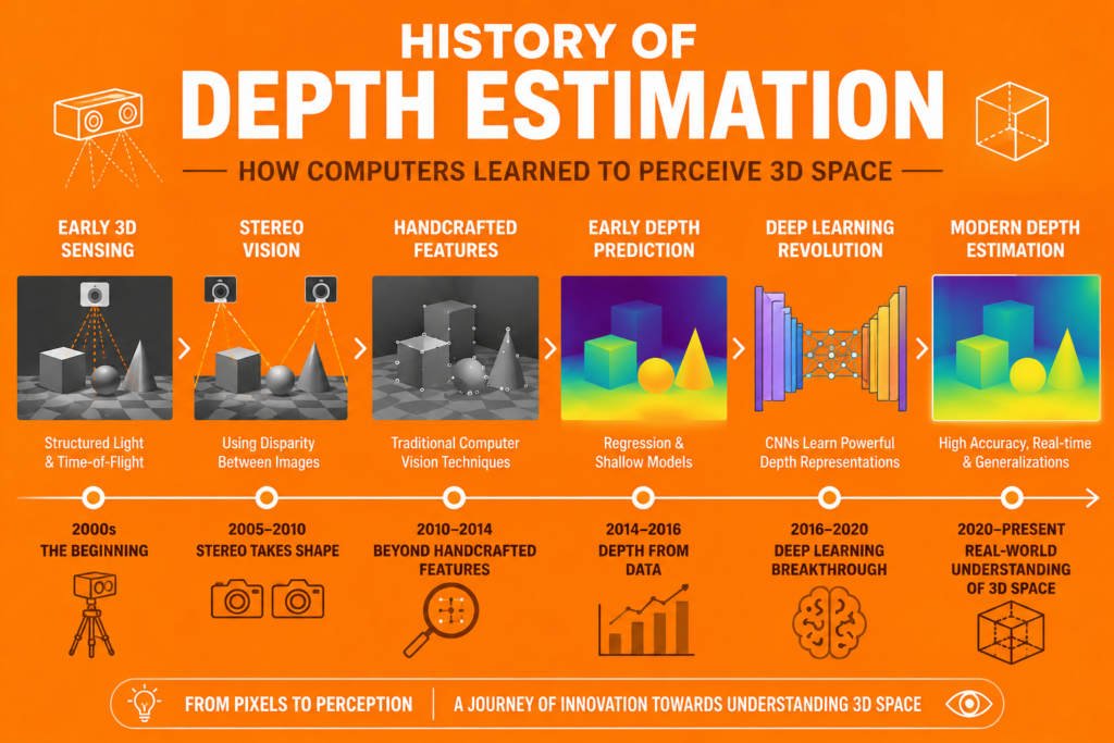
A photograph is fundamentally flat, a two-dimensional grid of pixels with no inherent sense of how far away anything actually is. Yet humans look at photographs and effortlessly perceive depth, understanding which objects are close and which are far away, almost without thinking about it. The history of depth estimation is the story of how computer vision systems learned to recover this missing dimension, moving from specialized hardware setups to deep learning systems that can estimate depth from a single ordinary photograph.
Why Depth Is Hard to Recover From Images
Scale ambiguity resolution captures the fundamental challenge underlying the history of depth estimation. A single 2D image is, mathematically, a projection of a 3D scene onto a flat plane, and this projection process loses information. A large object far away can produce exactly the same image as a small object placed close to the camera. Without additional information, there is no way to distinguish between these two scenarios from a single image alone.
This challenge connects to the broader history of computer vision, since depth estimation represents one of the clearest examples of a problem where the information needed for a task is not directly present in the raw pixel data, but must be inferred using additional assumptions, multiple viewpoints, or learned patterns from training data.
Stereo Vision: The First Solution (1960 – 1980)
Stereoscopic disparity calculation represents the earliest and most intuitive approach to the history of depth estimation, directly inspired by how human binocular vision works. By using two cameras positioned a known distance apart, similar to how human eyes are positioned, a system can capture two slightly different views of the same scene.
Epipolar geometry principles provide the mathematical framework for understanding the relationship between these two views. For any point in the 3D scene, its projections in the two camera images are related by specific geometric constraints determined by the cameras’ positions and orientations relative to each other. History of stereo depth matching algorithms focused on finding corresponding points between the two images, points that represent the same physical location in the scene as seen from each camera’s perspective.
History of disparity map calculations computer vision describes the output of this matching process. Disparity refers to the difference in position between corresponding points in the two images. Objects closer to the cameras produce larger disparities, while objects farther away produce smaller disparities, similar to how holding a finger close to your face and alternately closing each eye makes the finger appear to jump by a larger amount than a distant object would.
This early work connects directly to the first computer vision experiments of the 1960s, as researchers including Lawrence Roberts grappled with extracting three-dimensional structure from visual information, even if the specific stereo matching techniques developed somewhat independently from the block world experiments more commonly associated with that era.
Structure From Motion: Depth Without Stereo Cameras (1980 – 2000)
Traditional structure from motion depth estimation history represents an important generalization of stereo vision principles. Rather than requiring two cameras simultaneously capturing the same scene, structure from motion techniques could work with a single moving camera, using multiple images captured from different positions over time as the camera moved through a scene.
The underlying mathematics shares significant overlap with stereo vision, since multiple images of the same scene from different viewpoints provide the geometric constraints needed to recover depth information, similar to how two simultaneous camera views do. However, structure from motion introduced additional complexity, since the relative positions and orientations of the camera at different points in time were generally unknown and needed to be estimated as part of the overall reconstruction process, alongside the depth information itself.
History of optical flow depth maps represents a related approach during this period. Optical flow, the apparent motion of points within a video due to relative motion between the camera and the scene, could provide information about relative depth, since points closer to the camera typically exhibit larger apparent motion than points farther away, for a given camera movement.
This period overlaps significantly with the broader history of image processing, since extracting and matching features across multiple images, a core requirement for both stereo vision and structure from motion, relies heavily on image processing techniques developed for other purposes as well.
Active Depth Sensing: Measuring Distance Directly (1990 – 2015)
Development of passive vs active depth sensing describes an important distinction in approaches to depth estimation. The stereo and structure from motion approaches discussed so far are passive, relying entirely on analyzing images captured under normal lighting conditions. Active depth sensing, by contrast, involves the sensor itself emitting some form of signal and measuring how that signal interacts with the environment.
Evolution of time of flight depth sensing systems represents one important category of active sensing. Time of flight sensors emit pulses of light, often infrared, and measure how long it takes for that light to travel to objects in the scene and reflect back to a sensor. Since the speed of light is known precisely, this travel time can be converted directly into a distance measurement for each point in the scene.
History of lidar camera cross calibration depth tech became increasingly important as systems combined multiple sensor types. LiDAR, which uses laser pulses similarly to time of flight sensors but typically with greater range and precision, became an important reference technology, particularly in applications like self-driving cars and computer vision, where Ground truth LiDAR scans could be used both directly for depth measurement and as training data for camera-based depth estimation systems, helping these systems learn to estimate depth from images alone by comparing their predictions against LiDAR measurements during training.
Depth from focus techniques represent another category of approach, exploiting the fact that objects at different distances from a camera will be in focus at different focal settings. By capturing multiple images at different focus settings and analyzing which regions are sharpest at each setting, depth information could be inferred, though this approach generally required specialized equipment and controlled capture conditions rather than working with arbitrary single images.
Deep Learning and Monocular Depth Estimation (2014 – 2018)
Evolution of monocular depth estimation networks represents perhaps the most significant shift in the entire history of depth estimation. Monocular depth estimation refers to estimating depth from a single image, captured by a single camera, without stereo pairs, multiple viewpoints, or active sensing hardware, a task that seems to directly contradict the fundamental challenge of scale ambiguity resolution discussed earlier.
Monodepth and deep learning depth mapping history shows how this apparent contradiction was addressed. Rather than relying on explicit geometric reasoning from multiple images, deep learning approaches learned statistical relationships between visual appearance and depth from large datasets of images paired with ground truth depth information, often captured using the active sensing technologies discussed previously.
Depth map regression from single images timeline traces how these approaches evolved, drawing on the broader deep learning transformed computer vision narrative following the history of AlexNet in 2012. Convolutional neural networks, similar to those used for the history of image segmentation, could be trained to take a single image as input and output Dense depth map matrices, a value for every pixel indicating its estimated distance from the camera.
NYU Depth Dataset V2 became an important benchmark during this period, providing a substantial collection of indoor scenes paired with depth measurements captured using active sensors, allowing researchers to train and evaluate monocular depth estimation systems on a common dataset.
Self-Supervised Approaches: Learning Without Ground Truth (2017 – 2024)
Self-supervised depth learning represents an important development addressing a practical limitation of the supervised approaches described above: ground truth depth data, typically captured using LiDAR or other active sensors, can be expensive and time-consuming to collect at the scale needed to train large deep learning models effectively.
Self-supervised approaches instead leverage the geometric relationships inherent in stereo pairs or video sequences, similar in spirit to the classical stereo and structure from motion approaches discussed earlier, but using these relationships as a training signal for a deep network rather than as a direct computation method. A network might be trained to predict depth such that, when used to warp one image to match another from a slightly different viewpoint, the result closely matches the actual second image, providing a training signal without requiring separately collected ground truth depth data.
Relative vs absolute depth became an important distinction within this body of research. Many self-supervised and even some supervised approaches could learn to predict relative depth accurately, correctly identifying which objects are closer or farther than others, more easily than absolute depth, the actual physical distance in real-world units like meters. Converting relative depth predictions into absolute measurements often required additional calibration information or assumptions.
Depth Estimation in Practice Today (2018 – 2026)
Pixel point cloud reconstruction represents one important application building on modern depth estimation capabilities. By combining depth estimates for every pixel in an image with information about the camera’s properties, a 3D point cloud, a collection of points in 3D space corresponding to surfaces in the original scene, can be reconstructed, useful for applications ranging from 3D scanning to augmented reality.
This connects to the broader history of augmented reality, where understanding the depth and structure of a real-world environment is essential for placing virtual objects convincingly within that environment. It also connects to medical imaging ai, where depth and 3D structure information can be important for certain imaging modalities and analysis tasks, and to drones and computer vision, where depth estimation supports navigation and obstacle avoidance, particularly for platforms where the weight and power requirements of active depth sensors may be impractical.
Frequently Asked Questions
What is monocular depth estimation?
Monocular depth estimation is the task of estimating the distance from the camera to every point in a scene using only a single image, without stereo cameras, multiple viewpoints, or active depth sensors. Modern approaches generally use deep learning models trained to recognize visual cues associated with depth, such as object size, perspective, and texture patterns.
How does stereo vision estimate depth?
Stereo vision estimates depth by using two cameras positioned a known distance apart to capture two slightly different views of the same scene. By finding corresponding points between the two images and measuring their disparity, the difference in their positions, the system can calculate depth, with larger disparities corresponding to closer objects.
What is the difference between active and passive depth sensing?
Passive depth sensing relies entirely on analyzing images captured under normal conditions, such as stereo vision or structure from motion. Active depth sensing involves the sensor itself emitting a signal, such as infrared light pulses in time of flight sensors or laser pulses in LiDAR, and measuring how that signal interacts with the environment to determine distances directly.
What is self-supervised depth learning?
Self-supervised depth learning trains depth estimation models without requiring separately collected ground truth depth data. Instead, it leverages geometric relationships between stereo pairs or video frames, training a network to predict depth values that, when used to relate different views of a scene, produce consistent results, providing a training signal derived from the data itself.
Why is scale ambiguity a problem in depth estimation?
Scale ambiguity refers to the fact that a single 2D image cannot distinguish between a large object far away and a small object placed close to the camera, since both can produce identical images. This is a fundamental challenge for depth estimation from single images, addressed in modern approaches through learned visual cues and, when needed, additional calibration information for absolute depth measurements.
Conclusion
The history of depth estimation moves from stereo vision setups directly inspired by human binocular vision, through structure from motion techniques that extended these principles to single moving cameras, to active sensing technologies like time of flight and LiDAR that measure distance directly, and finally to deep learning systems capable of estimating depth from a single ordinary photograph, trained with or without explicit ground truth measurements.
Within the broader story of computer vision technology, depth estimation represents a particularly elegant example of how a fundamental limitation, the loss of three-dimensional information when a scene is projected onto a flat image, can be addressed through multiple complementary approaches, geometric reasoning, specialized hardware, and learned statistical patterns, each contributing to the broader goal of giving machines genuine spatial understanding of the world around them.